Wetlands of Porbandar
Porbandar can be described as plain sloping from Barda hills to the sea-coast, near which
are
tracks
of marshy land known as Ghed. Total 226 wetlands are mapped including 95 small wetlands (<
2.25 ha) with 22199 ha area in Porbandar district. Inland wetlands contribute 27.3% of
the total wetland area and coastal wetlands contribute 72.7% of the total wetland area.
Major wetland categories of the district are Lagoons, Rivers/ streams, Reservoirs and
Sand/beach. Area under aquatic vegetation in post-monsoon is about 5451 ha. Open water
spread of the wetlands is significantly higher in post monsoon (13390 ha) than during
pre monsoon (7376 ha). Mokarsagar Wetland Complex (previously known as Gosabara) is the
name given to the cluster of wetlands including Medha creek, Kuchhadi, Subhashnagar,
Zavar, Karly I, Karly II, Vanana, Dharampur, Gosabara, Bhadarbara, Mokarsagar,
Bardasagar and Amipur wetlands of Porbandar district of Gujarat.
Porbandar can be described as plain sloping from Barda hills to the sea-coast, near which are tracks of marshy land known as Ghed. Total 226 wetlands are mapped including 95 small wetlands (< 2.25 ha) with 22199 ha area in Porbandar district. Inland wetlands contribute 27.3% of the total wetland area and coastal wetlands contribute 72.7% of the total wetland area. Major wetland categories of the district are Lagoons, Rivers/ streams, Reservoirs and Sand/beach. Area under aquatic vegetation in post-monsoon is about 5451 ha. Open water spread of the wetlands is significantly higher in post monsoon (13390 ha) than during pre monsoon (7376 ha). Mokarsagar Wetland Complex (previously known as Gosabara) is the name given to the cluster of wetlands including Medha creek, Kuchhadi, Subhashnagar, Zavar, Karly I, Karly II, Vanana, Dharampur, Gosabara, Bhadarbara, Mokarsagar, Bardasagar and Amipur wetlands of Porbandar district of Gujarat.
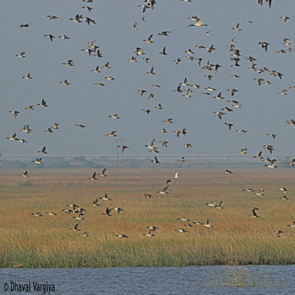
Ecologically Mokarsagar wetlands complex represents a diverse biotope. The wetland complex is a lifeline for the community as well as the wetland dependent biodiversity including both the flora (mangrove, macroalgae, macrophytes) and fauna (birds, reptiles, insects and mammals). A continuous stretch of Porbandar Bird Sanctuary, Chaaya –I, Chaaya-II and Porbandar Rann talao forms a Rann of approximately 10 sq km which is separated from the Mokarsagar wetland complex through a Jadeswar Road. Kuchhadi–Jhavar wetland adjacent to Shaurastra salt pan in Subhashnagar (also known as Karly creek) is another wetland complex of 4-5 sq. km is connected with the wetland complex through a patch of tidal mud with of 4-5 km mangrove patch via Karly I and Karly II wetlands. While two manmade Amipur reservoir of 15.81 sq km and Barda Sagar of 18-20 sq. km are important wetlands which during heavy rainfall attach with each other to form a vast expand of water of about 200 sq km. Shree Sahajanand Swami District Community Science Centre (SSDCSC)- Porbandar in the collaboration with Porbandar Forest Division- Porbandar, Indian Coastguard- Porbandar, Green Wildlife Conservation Society and Mokarsagar Wetland Conservation Committee organised Asian Waterbird Census (AWC) on 1st February- 2015 at 21 different sites of Porbandar district and recorded 1,93,358 waterbirds.